 1800 North | SR-37 | Clinton & Sunset | Improved Mobility
1800 North | SR-37 | Clinton & Sunset | Improved Mobility
Project Overview
Project Overview
This project is an effort to improve east/west mobility in northern Davis County by adding an interchange at 1800 North and I-15, widening 1800 North to 2000 West, and creating a new area where Hill Air Force Base can create an additional entrance gate in the future. The design includes seven lanes from I-15 to 250 West, five lanes from 250 West to 2000 West, and a new bridge over the rail crossing.
Benefits
- Meet the current and future traffic demands
- Accommodate and support all modes of transportation
- Provide a safe and efficient travelling experience for commuters of every kind
- In partnership with Sunset and Clinton, make improvements to local infrastructure to reduce disruption to the community
Download a project flier below:
Rendering of 1800 North from I-15 to 250 West.

Rendering of 1800 North from 250 West to 2000 West.

Open House Information
If you missed the open house we held on Wednesday, April 23, 2025, you can see the presentation materials by following the link Open House Materials.
Utility Coordination
Before we begin the work to actually widen the road, we coordinate with utility owners and local municipalities to complete all the necessary adjustments to the utility lines under the road. On this project, we have coordinated with 23 different utility company providers - with 13 or more working up and down 1800 North at any given time.
Sometimes utilities are required to move because of the road improvements (moving power poles near the new sidewalk location, for example) and sometimes service providers take the opportunity that comes with exposing the road to upgrade their services (larger water lines to provide more service to growing neighborhoods or upgrades to aging infrastructure, for example).
From the driver’s eye view, this can look like repetitive work – digging up a trench, laying pipe, compacting it, and doing it all over again for the next service. The network of pipes and conduit under the road can be as congested as the cars that drive on top of it. Additionally, utilities have spacing requirements to keep clearance from other pipes in their final placement. These considerations require careful planning during the engineering design and skilled placement during construction.
While this work may require road closures and be frustrating to those who drive in the area, it’s a necessary step in delivering the services we’ve come to expect in our modern lives – flushing toilets, clean drinking water, high speed internet, heat during the winter and air conditioning during the summer. The good news is, once the road is constructed, we push pause on permits and requests to cut into the road, emergencies notwithstanding. The utility and road work happening now is just about all of the work that will take place for the next several years.
Area Map
The following map is intended to be a visual representation of the design concept and not a final design. These plans are subject to change.
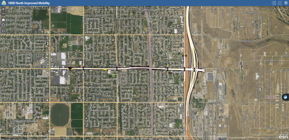
Project Area Map
The project extends from 2000 West eastward to the proposed new access gate for Hill Airforce Base just east of the new I-15 alignment, a new single point urban interchange at 1800 North on I-15, along with modifications to I-15 between 650 North in Clearfield to 5600 South in Roy.

Project Milestones
The following are anticipated milestone dates and are subject to change.

Schedule
Work Hours: 7:00 a.m. - 6:00 p.m.
Workdays: Monday - Friday
Schedules are subject to change due to weather conditions and material availability.
Contact Information
To contact the public information team with questions or concerns:
Hotline: 385-383-6576
Email: 1800north@utah.gov
Stay Informed
To receive weekly construction updates, fill out the form on the Contact Us! page or contact the public information team at the email address above and enter "Project Updates" in the subject line.
Area Projects
Learn more about the 5600 South project (Roy).
Learn more about the 2000 West project (West Point to Clinton).
Learn more about the SR-108 project (Clinton to West Haven).