Overview

UDOT completes Big Cottonwood Canyon environmental study 

Transit improvements aimed at reducing winter traffic may begin as early as 2028

Click the “Updates” tab for more details.

Study Overview

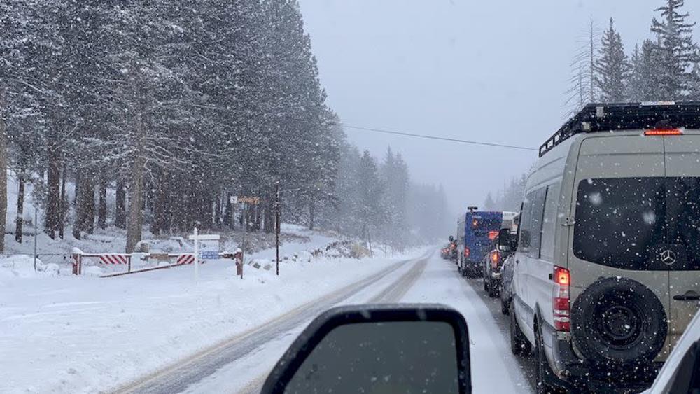
Transportation needs in Big Cottonwood Canyon are primarily related to traffic congestion during peak periods (typically 7-9 a.m. and 3-5 p.m.) during the ski season and anticipated future increase in visitation as a result of population and tourism growth in Utah.

The Utah Department of Transportation (UDOT) conducted an environmental study to to address winter-time traffic congestion on State Route (SR) 190 in Big Cottonwood Canyon as directed by the Utah State Legislature in Senate Bill 2 (SB 2) (2023).

SB 2 specifies and directs UDOT to use certain legislature-allocated funds to “provide enhanced bus service, tolling, a mobility hub, and resort bus stops for Big and Little Cottonwood Canyons.”

Project elements that we’re considering as part of the Big Cottonwood Canyon Environmental Assessment include:

  • Enhanced bus service 
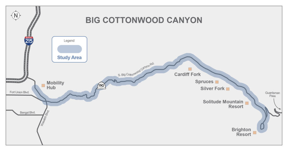
  • Mobility hub at bottom of Big Cottonwood Canyon with a grade-separated interchange on Wasatch Boulevard to access the mobility hub
  • Resort bus stops
  • Improvements to the existing bus stops located at Silver Fork, Cardiff Fork, Spruces Campground, and Silver Lake/Solitude Nordic Center 
  • Tolling
  • Bus priority features, including a bus only lane at the Brighton Loop, intended to improve enhanced bus service operations and performance

This environmental study was prepared in accordance with the National Environmental Policy Act (NEPA).

Proposed Action

An illustrated topographic map shows the winding blue path of SR-190 through Big Cottonwood Canyon. On the far left, at the canyon base, callouts identify a Grade-Separated Interchange on Wasatch Blvd and a Mobility Hub with 1,750 Parking Stalls. Moving up-canyon, orange icons indicate Bus Stop Improvements at Cardiff Fork, Spruces Campground, Silver Fork, and Silver Lake. Green icons mark the Solitude Mountain Resort and Brighton Resort bus stops. A blue label indicates Tolling Starts Below Solitude Entry 1, and a yellow line highlights the Bus Priority Lane around the Brighton Loop.

Project Timeline

A dark blue horizontal timeline graphic displays the project’s schedule from 2026 to 2028 white text, divided into four main phases. White text and icons read from left to right in a bulleted list.  2026 - Start Design and Bus Service Procurement: Accompanied by a bus icon with bullet points for ordering buses, soliciting a bus operator, and hiring final design engineers and architects.  2027 - Final Design & Permitting: Accompanied by a checklist icon with bullet points for  final designs for mobility hub, Wasatch Blvd. interchange and transit-way, bus stops at Solitude and Brighton, bus priority lane, and mid-canyon bus stops.  2027 - Property Acquisition & Construction: Accompanied by an icon of two people shaking hands over a dollar sign with bullet points for  securing right-of-way (ROW) and starting construction.  2028 - Implementation (Fall): Accompanied by a construction worker icon with bullet points for enhanced bus service begins, construction complete, and tolling operational

Study Area Map

A map with a gray background titled "BIG COTTONWOOD CANYON" shows a light-blue shaded line called "Study Area" following the winding path of Big Cottonwood Canyon Rd. (SR 190). The map includes major connecting roads at the base, such as I-215, Fort Union Blvd., Bengal Blvd., and Wasatch Blvd. Orange squares identify specific locations along the canyon route, starting with a Mobility Hub at the base and continuing up-canyon to Cardiff Fork, Spruces, Silver Fork, Solitude Mountain Resort, and Brighton Resort. An arrow also indicates the direction of Guardsman Pass near the top of the canyon.

Standstill traffic in Big Cottonwood Canyon during a winter snowstorm.


The environmental review, consultation, and other actions required by applicable Federal environmental laws for this project are being, or have been, carried out by UDOT pursuant to 23 U.S.C. 327 and a Memorandum of Understanding dated May 26, 2022, and executed by FHWA and UDOT.​

For more information on the Big Cottonwood Canyon Environmental Assessment (EA), click here.

Study Process & Schedule

Project Timeline

complete
complete

Decision

Spring 2026

  • Issue decision document (FONSI)
  • Revise environmental document as appropriate
  • Respond to public comments
  • Stakeholder working group meeting
  • Local government presentations
  • Public outreach

complete
complete

Environmental Assessment

Winter 2024 - Winter 2025

  • Refine action alternative
  • Analyze environmental impacts
  • Prepare and publish environmental document
  • Local government presentations
  • Stakeholder working group meeting
  • Public hearings (virtual and in person) and comment period
  • Public outreach

complete
complete

Scoping

Fall 2024 - Winter 2024

  • Existing conditions traffic analysis & projected 2050 no-action conditions
  • Develop study’s purpose and need 
  • Develop proposed concept 
  • Public Scoping meetings (virtual and in-person) and comment period
  • Local government presentations 
  • Stakeholder working group meeting  
  • Public outreach

complete
complete

Pre-Scoping Activities

Spring 2024 - Fall 2024 

  • Review of past studies
  • Identify environmental resources
  • Local government presentations
  • Stakeholder working group meeting
  • Public outreach

Contact Information

To contact the public information team with questions: 

Hotline: 801-477-6410

Emailbccstudy@utah.gov

Stay Informed

The environmental study is complete, please contact the public information team at the email address below and enter "More Information" in the subject line.

Emailbccstudy@utah.gov